
Map your Priorities for Nature
Priorities for Nature is a map-based information collection tool, somewhere you can share your ideas and priorities for nature.
Why we’ve developed a priority mapping tool
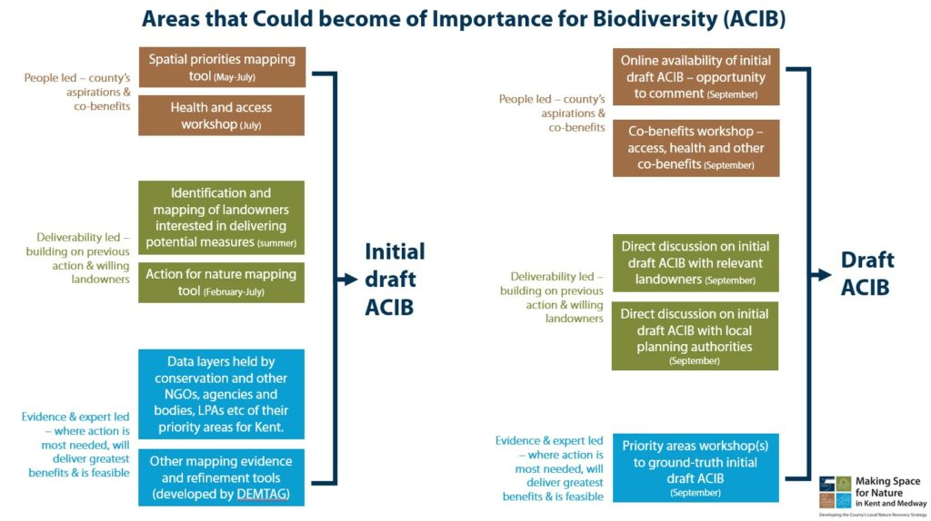
To develop our opportunities for nature and determine the “areas that have the potential to become of importance for biodiversity”, we will be pulling together information from many different sources. We will speak with experts and review evidence, to identify where action is most needed and where it will deliver the greatest wins for nature. We will look to build on previous action and find areas where there are landowners interested in participating in nature recovery. And we want to hear from the people of Kent, so that the strategy fully reflects the county’s aspirations.
MS4N Priorities for Nature mapping tool
The Priorities for Nature online mapping tool allows anyone and everyone to take part in the mapping element of the project – we want to hear where you would like to see nature recovery targeted, creating a wish list of locations for action that the project can draw on. Landowners can also use the tool to show the project where they’re interested in helping to support nature recovery, by mapping the relevant area and telling us what they would like to see their land used for. As well as mapping your own priorities, you can also view what others have submitted and express your support, or not, for that proposal.
How your mapped areas will be used in the project
Whilst the final map for the county cannot feature all proposed areas for action, by submitting the area you’d like to see included, and the nature recovery aspirations you have for it, the project will have the most complete picture to create the map from. It will also help us, and our delivery partners, understand what and where is really important to the people of Kent and the opportunities that might exist for nature recovery – and even if not included in the mapped “areas that have the potential to become of importance for biodiversity”, all sites will be recorded and we can look to reflect any common themes in our wider priorities. Landowners who find their land incorporated into a mapped area should not be concerned – these mapped areas are aspirational, and suggestions only; it does not mean your land will feature in the final priority mapping.
What the “areas that have the potential to become of importance for biodiversity” map will provide
The outcome of this stage of the project will be the identification of opportunities for nature, with areas mapped that have the potential to become of importance for biodiversity. These maps will not dictate or force what must, or must not, be done on the land. However they will be instrumental in ensuring that action and investment is directed to where it is most needed and where it will deliver the best outcomes for nature recovery.
Next steps
Before the adoption of any mapping next year, there will be plenty of opportunities to have further input. In September we will publish the initial draft map of areas that have the potential to become of importance for biodiversity. Throughout the month and into October, there will be a series of workshops and online opportunities to comment; and we will also be speaking with stakeholders the mapped areas directly relate to. There will also be a full public consultation in early 2025. Whether a landowner or interested party, if you have any concerns about the mapping work, please contact the project on makingspacefornature@kent.gov.uk
For more information about this element of the work, and to see the latest updates, see What we want – mapping areas of opportunity
How to use the tool
 MS4N Priorities for Nature mapping tool
Straight away you can view what others have submitted on the map of Kent & Medway and the icons tell you what priority they relate to, for example “wetland” or “farmland and land management”. As the tool runs more and more pins will appear on the map.
If you click on a pin, the map zooms in – you can find out more about the action proposed and also gives you the option to lend your support or not, with a simple thumbs up/thumbs down button.
The tool has been deigned to be simple to use, so you might want to go straight in on the above link and click on the blue “Add Your Priority for Nature” button on the top right, but these are the steps you will go through:
- Click the blue “Add Your Priority for Nature” button and select the priority your ambition aligns with – use the “Next” button bottom left to move to each new step.
- You are then guided to either draw or upload the boundary for your priority, to draw it, click the draw a polygon button (pentagon shape) and mark an area on the map (if you need instructions click the question mark (?) button).
- You can then add your detail on “What action should be taken in this area” and the optional field “Why is this action needed?”
- There are then optional questions about your relation to the land and your interest in nature recovery.
- Finally check the privacy notice box and submit.
The MS4N team can also offer support to anyone wishing to map their action – please contact makingspacefornature@kent.gov.uk
We look forward to seeing all your priorities on the map!